May 12, 2013
The
arguments of those opposed to their use pretty much boil down to “reliance on
electronics makes you stupid.” There are all sorts of varieties of those
arguments, some descending into the absurd (“What if all the satellites went
out at once? What would you do then? Huh? HUH???”)

Here’s
a picture of mine. The model is Garmin 441S (the S stands for “sounder,”
because you can connect a depth sounder to it, and I strongly recommend that.)
If
you look at the picture, you’ll see a representation of my boat as she approaches the entrance
to a channel. It shows a line for me to follow, where the channel markers are,
and the depths of the waters surrounding my boat. It shows the path I’ve chosen
because I’ve saved the entrance to that channel as a “waypoint,” and told the
chart potter to guide me there. What’s not to love?
Well,
a couple of things. First of all, as you get all that detail, you lose the
bigger picture. Without that bigger picture, you might be entering the wrong
channel, just as an example of one thing that can go wrong. For another, the
chart plotter is only as good as the information you put into it, and it is
fairly complicated to learn how to put the waypoints in. It’s easy
to make a mistake entering the numbers. So unless you’re just a little bit anal and double
check what you’ve put in, you could end up going somewhere you didn’t intend.
Second,
although they will shortly be coming out with a chart plotter that remedies
this problem, the chart plotter I have will cheerfully steer me onto a sandbar
if I don't put in a path around it, a fairly complicated thing to do, or a
reef (they can really do a lot of damage to your boat), or through a restricted
area (where I live you will get to meet either the Coast Guard or the Air
Force, depending on where you’ve wandered). In other words, until the new
generation comes out, they can’t pick a safe route for you. You can use
your chart plotter badly and end up in a pickle.
Third,
they can malfunction. My chart plotter started telling me that I was always at
latitude 32º, which runs roughly through the middle of Georgia, while I live near
the midline of Florida. Every waypoint I had saved came up as being at latitude
32º. I took it back to the store, and they told me it needed a software update.
So if you get a chart plotter, check the manufacturer’s website from time to
time. Your chart plotter has to be able to talk the same language as the
signals it’s receiving, and sometimes that will mean an update.
That
takes us back to paper charts. You really should have paper charts of any
waters you’re going to sail. You can get the big picture, study it in detail,
note where the high spots and reefs are, and get a global feeling for where
you’re going. You can pick your waypoints by latitude and longitude on the big
chart, and then enter them that way on the chart plotter (as I said, double
check afterwards and make sure they’re right.)
However,
you can zoom in and zoom out with your chart plotter. The more you zoom in, the
less you have of the bigger picture, but the more detail you have about the
immediate area you’re in. You can’t zoom in on a paper chart. You can even hook
the chart plotter up to your computer and get a larger view if you want
(personally, I don’t risk having my computer in the cockpit – too many things
can happen to it, from a drink being spilled on it to having someone step on
it.)
The
paper chart, for instance, will show you where two channels intersect. The
chart plotter will not only show you that, but show you where your boat is as
well, so you know exactly where to turn. You wouldn’t think channel
intersections would be confusing, but on the water, they can be difficult to
sort out, especially when you first start sailing.
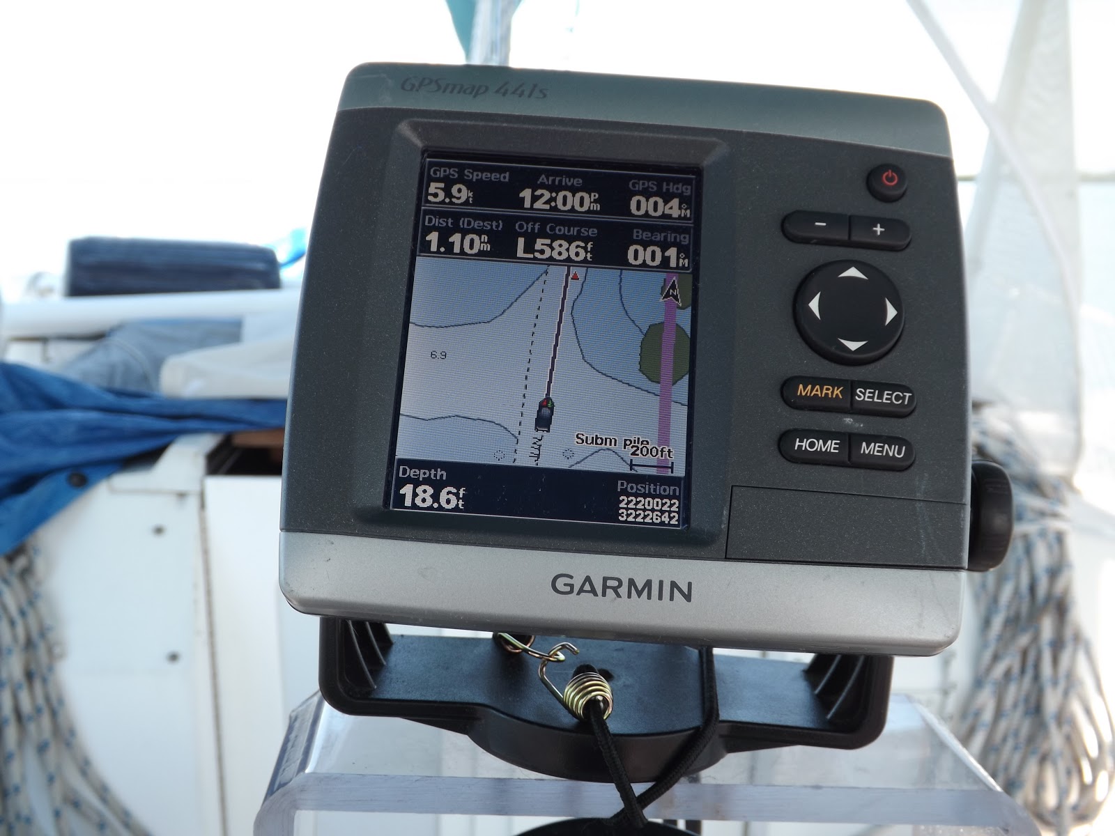
On
this chart plotter, the more shallow water is darker, and the deeper water is lighter, showing very clearly where the intersection is. I’m just about to make
a 90º turn to port at this point in order to turn into the east-west channel. You
can also see the depth of the water under my boat, which at 18.6’ is a clear
indication that I’m in the channel.
If
you look to the northwest of the boat, you’ll see some green. It looks like an
island, but it’s not. That’s the chart plotter letting me know that the water
in that area goes from very deep to very shallow, very rapidly (I mentioned
that in another article; here’s a visual representation of it). In rare extreme
tides, that area will be above the water, which is why it’s green. While
you’ll see that area as shallow on the paper chart, seeing where my boat is
puts that danger right in my face. Suppose I were very close to that spot? I
might not have time to look at the paper chart and estimate (which is all I
would be able to do) how close I was to it.
The
chart plotter can tell you a lot of things. It will give you your speed over
ground, or the current time, or what time it estimates you will get to the
waypoint you’ve selected. These are all choices you make in the menus, and
learning to wade through the menus will take some time and dedication. By
zooming in and out, you will get all the information on the paper chart. In addition it will have easy access to information about tides and currents.
So
where do I sit on this debate? Obviously I’m not opposed to the use of chart plotters,
but I think most people who argue about them miss one of their best features:
they can really help you learn how to read a paper chart. (Of course, the
people saying that chart plotters are crutches for lazy sailors have been
sailing a long time, and, I think, don’t remember how complicated it is to
learn all this stuff.) I recommend having a crew member take the latitude and
longitude off the chart plotter and on to the paper chart every half hour, so you can mark your
course. You can use a grease pencil and remove the marks when you’re done if
the chart is waterproof.
You’ll
learn a lot about using your paper chart from this practice. In addition, in
your cruising log, note the time as well as the latitude and longitude. Then,
if your chart plotter should go out (and that does happen), you’ll have a good
idea of where you are, and a good idea of how fast you’re moving across the
water. With that information, if the chart plotter should go out, you’ll be
able to use the paper chart much more effectively. (Update: someone on Cruisers Forum suggested including the compass heading in the log also, and I think that's a good idea.) You’ll be able to estimate
the distance you’ve traveled and make better guesses about where you are.
So,
my opinion is to use paper chart and chart plotter together, but intelligently. You do that, and your electronics won’t make you stupid. They will make you a more highly skilled
sailor.
No comments:
Post a Comment